Reliable navigation matters when trails, waterways, and backcountry routes take you beyond dependable cell service. The best waterproof handheld GPS devices combine durable construction, readable screens, accurate positioning, and controls you can use outdoors.
This roundup compares 10 options for hikers, boaters, hunters, and adventurers, from straightforward basic navigators to advanced units with multi-band reception and satellite messaging.
Best 10 Waterproof Handheld Gps Devices Picks for 2026
Reliable Trail Companion

- Sunlight-readable 2.2-inch color display
- TopoActive maps with routable trails
- Up to 25 hours on two AA batteries
Best For: Hikers and cyclists seeking simple, dependable navigation
Precision in Difficult Terrain

- Multi-band technology for challenging locations
- Routable TopoActive maps included
- 2.6-inch sunlight-readable color display
Best For: Outdoor navigation where positioning accuracy is a priority
Long-Running Navigator

- Up to 1,800 hours in expedition mode
- Multi-GNSS support and digital compass
- IPX7 water-resistant construction
Best For: Extended hikes and trips where battery life matters most
Satellite Safety and Navigation

- Two-way messaging and interactive SOS
- Large 3-inch sunlight-readable display
- Up to 425 hours in expedition mode
Best For: Remote travel requiring navigation and satellite communication
Best Budget GPS

- IPX7 water resistance
- GPS, GLONASS, and HotFix positioning
- Up to 20 hours on two AA batteries
Best For: Basic hiking, running, and geocaching navigation
Best Long-Battery GPS

- 3.2-inch sunlight-readable screen
- Up to 36 hours of rechargeable battery life
- USA topo maps with compass and altimeter
Best For: Extended hiking and camping trips
Best Floating Marine GPS
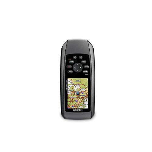
- IPX7-rated and floats in water
- Color display with worldwide basemap
- microSD support for additional maps
Best For: Boating, watersports, and marine navigation
Compact Trail Navigator

- Multi-GNSS support for challenging locations
- Up to 20 hours with USB-C recharging
- Track navigation, compass, and altimeter; no maps
Best For: Lightweight track-based hiking navigation
Water-Ready Marine Pick

- IPX6 water-resistant and floats in water
- Worldwide basemap and multi-constellation support
- Stores 10,000 waypoints and 250 routes
Best For: Boating, fishing, and water-focused navigation
Mapped Hiking Workhorse

- Preloaded TopoActive maps with routable trails
- Up to 25 hours on two AA batteries
- 8 GB storage plus microSD expansion
Best For: Mapped hiking and cycling routes
Reliable Trail Companion – Garmin eTrex 22x
For a straightforward option among waterproof handheld GPS devices, the Garmin eTrex 22x combines a rugged handheld design with a sunlight-readable color display, preloaded TopoActive maps, and support for GPS and GLONASS. Its button controls and long AA-battery runtime suit hiking, cycling, and general outdoor navigation.
Best For: Hikers and cyclists who want dependable mapping with simple button operation and replaceable batteries.
Pros:
- Preloaded TopoActive maps include routable roads and trails.
- GPS and GLONASS support can help with tracking in challenging environments.
- Up to 25 hours of battery life from two AA batteries.
- 8 GB of internal memory plus a microSD card slot supports map downloads.
Cons:
- The 2.2-inch display is smaller than those on the other listed models.
- It does not have a touchscreen.
The eTrex 22x is a practical choice when core navigation features, map storage, and easy-to-replace batteries matter more than advanced connectivity or satellite messaging.
Precision in Difficult Terrain – Garmin GPSMAP 65
The Garmin GPSMAP 65 is built for users who need greater positioning confidence from waterproof handheld GPS devices in difficult surroundings. Its expanded GNSS support and multi-band technology are designed for challenging locations such as forests, steep country, and urban canyons, while the 2.6-inch display keeps maps easy to view.
Best For: Hikers, hunters, and outdoor users who prioritize accurate positioning in obstructed environments.
Pros:
- Multi-band technology and expanded GNSS support target challenging locations.
- Includes routable TopoActive mapping and U.S. federal public land boundaries.
- Sunlight-readable 2.6-inch color display provides a larger viewing area.
- Works with the Garmin Explore website and app for tracks, routes, and waypoints.
Cons:
- Battery life is listed at up to 16 hours, shorter than several alternatives here.
- A compatible smartphone is required for Garmin Explore features.
The GPSMAP 65 makes the most sense when satellite accuracy in complex terrain is a higher priority than maximum battery endurance or built-in satellite communication.
Long-Running Navigator – Garmin eTrex SE
The Garmin eTrex SE stands out among waterproof handheld GPS devices for its exceptional battery life and compact design. It offers a sunlight-readable 2.2-inch display, multi-GNSS support, a digital compass, wireless smartphone features, and an IPX7 water-resistant rating for hiking in changing weather.
Best For: Backpackers and hikers who want very long battery life, basic navigation, and smartphone-connected features.
Pros:
- Runs for up to 168 hours in standard mode or 1,800 hours in expedition mode.
- Supports GPS, GLONASS, Galileo, BeiDou, and QZSS satellite systems.
- IPX7 water-resistant design is suited to hiking in wet conditions.
- Garmin Explore pairing enables wireless updates, trip planning, and additional features.
Cons:
- Two AA batteries are field-replaceable but not included.
- Several connected features require a compatible smartphone.
- The display is relatively compact at 2.2 inches.
Choose the eTrex SE if minimizing battery changes is central to your trips. It delivers unusually long operating times while retaining a simple button-operated navigation experience.
Satellite Safety and Navigation – Garmin GPSMAP 67i
The renewed Garmin GPSMAP 67i adds two-way satellite messaging and interactive SOS to the core navigation features expected from waterproof handheld GPS devices. It combines multi-band GNSS, preloaded TopoActive maps, a large sunlight-readable display, and a rechargeable battery designed for extended tracking.
Best For: Remote travelers who need navigation plus satellite communication and emergency-response capability.
Pros:
- Two-way messaging and interactive SOS use the global Iridium satellite network.
- Large 3-inch sunlight-readable color display supports easier map viewing.
- Battery lasts up to 165 hours in 10-minute tracking mode or 425 hours in expedition mode.
- Includes multi-band GNSS, TopoActive mapping, and satellite imagery access.
Cons:
- An active subscription is required for messaging and SOS features.
- This is a renewed product with a listed 90-day limited warranty.
- Its rechargeable battery cannot be swapped in the field like AA batteries.
The GPSMAP 67i is the most capable option here for remote trips where staying in contact matters. Its subscription-based satellite services add ongoing cost, but they provide functionality beyond navigation alone.
Best Budget GPS – Garmin eTrex 10
The Garmin eTrex 10 is a straightforward choice for shoppers comparing waterproof handheld GPS devices for hiking, geocaching, and general outdoor navigation. Its monochrome 2.2-inch display, worldwide basemap, WAAS-enabled GPS receiver, and support for GPS and GLONASS prioritize dependable basic navigation over advanced mapping.
Best For: Budget-conscious hikers, runners, and geocachers who want a compact, button-operated navigator with long battery life.
Pros:
- IPX7 water resistance helps protect against rain and splashes.
- GPS, GLONASS, and HotFix support help provide fast positioning and a reliable signal.
- Two AA batteries provide up to 20 hours of use.
- Supports paperless geocaching, waypoint storage, and track elevation details.
Cons:
- The 2.2-inch monochrome display is basic compared with color-screen GPS units.
- Its 6 MB storage is limited for extensive map data.
- The worldwide basemap may not provide the detail of dedicated topographic maps.
Choose the eTrex 10 when reliable essentials matter more than a large display or detailed downloadable maps. It is especially practical for users who prefer replaceable AA batteries and simple physical-button operation.
Best Long-Battery GPS – NiesahYan Rugged Handheld GPS
This NiesahYan navigator is a feature-focused option among waterproof handheld GPS devices, combining a sunlight-readable 3.2-inch screen with USA topo maps and multi-GNSS support. Its rechargeable battery, compass, barometric altimeter, and 32 GB of internal memory make it suited to longer outdoor trips.
Best For: Hikers and campers who want a readable non-touchscreen display, extended battery life, and built-in USA topographic mapping.
Pros:
- The 3.2-inch screen is designed to remain readable in bright sunlight.
- GPS, Galileo, BeiDou, and QZSS support can improve positioning flexibility.
- Up to 36 hours of rechargeable battery life, with USB-C charging.
- Includes a 3-axis compass, barometric altimeter, USA topo maps, and 32 GB of storage.
Cons:
- Its IP66 rating is water-resistant protection, not the same as full submersion protection.
- The display is non-touchscreen, so operation relies on physical buttons.
- The supplied notes do not identify a specific map-update schedule.
The NiesahYan stands out for its larger sunlight-readable screen, long runtime, and built-in outdoor sensors. Consider it if those features are more important than the stronger submersion rating offered by some competing handhelds.
Best Floating Marine GPS – Garmin GPSMAP 78
The Garmin GPSMAP 78 is a marine-oriented choice for shoppers seeking waterproof handheld GPS devices for boating, watersports, hunting, or outdoor recreation. It combines an IPX7-rated floating design with a high-sensitivity GPS receiver, color display, worldwide basemap, and microSD expansion.
Best For: Boaters and watersports users who need a floating, water-resistant handheld with chart-loading flexibility.
Pros:
- IPX7 waterproof construction and a floating design suit marine use.
- High-sensitivity GPS receiver and Garmin HotFix support help with positioning.
- Worldwide basemap and microSD card slot support additional map loading.
- Supports Garmin Connect, geocaching GPX files, automatic routing, and custom points of interest.
Cons:
- Two AA batteries provide about 20 hours of use, less than the longest-lasting rechargeable option here.
- The 2.6-inch color display is relatively compact for detailed chart viewing.
- AA batteries are not included.
For water-based navigation, the GPSMAP 78’s ability to float may be its most practical advantage. Its expandable storage and marine-friendly construction also make it more versatile than a basic handheld GPS, provided you are comfortable carrying spare AA batteries.
Compact Trail Navigator – A6 Handheld GPS for Hiking
For hikers seeking waterproof handheld GPS devices with a compact design, the A6 offers a bright 2.4-inch color display, multi-GNSS support, and track-based navigation. Its rechargeable battery runs for up to 20 hours, but note that this model does not include maps.
Best For: Hikers who want lightweight track recording, waypoint storage, and return-to-start guidance without built-in maps.
Pros:
- Supports GPS, Galileo, BeiDou, and QZSS for positioning in challenging environments.
- Up to 20 hours of continuous use with convenient USB-C recharging.
- Includes a compass, barometric altimeter, sunrise and sunset information, track recording, and waypoint storage.
- Compact 2.4-inch sunlight-readable color screen.
Cons:
- Does not include maps.
- Requires an open-sky satellite search before use for best accuracy.
The A6 is a practical choice when portability and long battery life matter more than mapped route planning. Its track navigation tools are useful for retracing a hike, while the lack of maps makes it better suited to users who already plan routes elsewhere.
Water-Ready Marine Pick – Garmin GPSMAP 79s
Garmin GPSMAP 79s, Marine GPS Handheld with Worldwide Basemap, Rugged Design and Floats in Water
Check Price On AmazonThe Garmin GPSMAP 79s stands out among waterproof handheld GPS devices for water-based use, combining an IPX6 water-resistant design with the ability to float. It also includes a worldwide basemap, multi-constellation satellite support, and storage for extensive waypoint and route collections.
Best For: Boaters, anglers, and outdoor users who need a rugged handheld GPS that floats and remains easy to manage on the water.
Pros:
- Rugged IPX6 water-resistant construction and floating design.
- High-resolution color display with scratch-resistant, fogproof glass.
- Supports GPS, GLONASS, BeiDou, Galileo, QZSS, and SBAS.
- Stores up to 10,000 waypoints, 250 routes, and 300 activities.
Cons:
- IPX6 protection is specified at the unit level only.
- Battery life is up to 20 hours in GPS mode.
With its floating body, marine-oriented design, electronic compass, and barometric altimeter, the GPSMAP 79s is particularly well suited to boating and fishing. Its substantial waypoint and route capacity also benefits users who maintain detailed outdoor trip records.
Mapped Hiking Workhorse – Garmin eTrex 32x
The Garmin eTrex 32x is a dependable option for shoppers comparing waterproof handheld GPS devices for hiking and cycling. It pairs a sunlight-readable color display with preloaded TopoActive maps, routable roads and trails, expandable storage, and up to 25 hours of battery life from two AA batteries.
Best For: Hikers and cyclists who want built-in topographic mapping, route support, and long replaceable-battery runtime.
Pros:
- Preloaded TopoActive maps include routable roads and trails.
- Supports GPS and GLONASS for tracking in challenging environments.
- Includes 8 GB of internal memory and a microSD card slot.
- Up to 25 hours of GPS use with two AA batteries.
Cons:
- Its 2.2-inch display is smaller than the GPSMAP 79s display.
- Uses two AA batteries rather than a rechargeable battery.
The eTrex 32x is the strongest fit here for users who want maps already loaded onto the device. Its compass, barometric altimeter, expandable storage, and long AA-powered runtime make it a versatile choice for extended hikes and cycling trips.
How We Picked These Waterproof Handheld Gps Devices
We focused on handheld navigators suited to demanding outdoor conditions, prioritizing water resistance, satellite reception, durability, usability, mapping features, and battery practicality. The selection includes simple entry-level models, marine-focused devices, modern multi-GNSS units, and advanced options with inReach satellite communication.
We also considered how clearly each device serves a specific use case. A basic GPS may be the better choice for occasional hiking, while a high-end model can justify its cost for remote travel, emergency communication, or frequent navigation in difficult terrain.
Quick Comparison
| Best For | Look For | Potential Trade-Off |
|---|---|---|
| Budget hiking | Simple waypoint and track navigation | Smaller screens and fewer maps |
| General outdoor use | Color display, expandable storage, long battery life | Higher purchase price |
| Dense terrain | Multi-band GNSS and expanded satellite support | More features to configure |
| Remote emergencies | Two-way satellite messaging and SOS | Requires a service plan |
| Boating | Floating design, marine maps, and water-resistant controls | May be less convenient for trail use |
Key Buying Factors for Waterproof Handheld Gps Devices
Waterproofing and Durability
Check the exact water-resistance rating rather than relying only on the word “waterproof.” A rugged housing, sealed buttons, and a design that can withstand drops are especially important for kayaking, boating, fishing, and wet-weather hiking. If you are on the water, a floating model adds useful protection against accidental loss.
Satellite Accuracy and Reception
Multi-GNSS support can improve positioning availability, while multi-band technology may provide more consistent accuracy near cliffs, buildings, or dense vegetation. For ordinary open-trail navigation, a reliable standard receiver may be sufficient.
Maps, Screen, and Controls
Color maps are easier to interpret than basic monochrome displays, but screen quality affects both price and battery life. Look for a sunlight-readable display and controls you can operate with gloves or wet hands. Confirm whether detailed maps are included, downloadable, or purchased separately.
Battery Life and Charging
Compare claimed runtime with your trip length and charging options. Replaceable AA batteries are convenient for extended trips, while rechargeable systems can be simpler for regular use. Carry backup power for multi-day excursions.
Satellite Messaging
Two-way messaging and interactive SOS can be valuable where cellular coverage is unavailable, but these functions typically require an active subscription. Treat them as a safety feature, not a substitute for trip planning and emergency equipment.
Who Should Buy Which Waterproof Handheld Gps Devices?
Choose an entry-level eTrex-style navigator if you want dependable basic tracking at a lower cost. A color-screen general-purpose model is a better fit for hikers and campers who regularly follow routes and use waypoints. Pick a multi-band GPSMAP model for challenging reception conditions or more demanding navigation.
For remote expeditions, solo travel, or backcountry work, an inReach-equipped device is the strongest choice when satellite communication and SOS capability justify the ongoing subscription. Boaters should prioritize floating construction, marine chart support, and controls that remain practical around water.